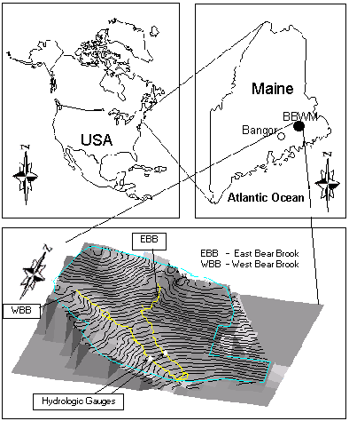
The Bear Brook Watershed of Maine (BBWM) was selected as a test watershed for evaluating the OWLS model. The BBWM (See Figure) is located in eastern Maine (44°52'15" Latitude, 68°06'25" Longitude), approximately 60 kilometers from the Atlantic coastline in the northeastern United States. The BBWM is a paired watershed study funded by U.S.EPA since 1987 as part of The Watershed Manipulation Project (WMP) within the National Acid Precipitation Assessment Program (NAPAP). NAPAP was designed to assess the causes, effects, and strategies for controlling acidic precipitation.
The major purposes of the BBWM project are to:
(1) Identify and quantify the major processes that control surface water acidity, with a major emphasis on the role of excess sulfate and nitrate and the rate of cation supply through chemical weathering and cation desorption;
(2) Assess the quantitative and qualitative response at the watershed level to different (both increased and decreased) levels of acidic deposition;
(3) Evaluate the ability of existing models of water acidification to predict short- and long-term chemical variations in surgace water chemistry and to predict watershed soil response to increased and decreased loading of strong acids.
As a long-term research watershed, the BBWM includes bench-scale, micro-site, plot, and whole watershed investigations. The associated data bases are ideally suited for watershed hydrologic and chemical simulations at a watershed scale. Thus, it represented an ideal watershed to test the OWLS model.
The study site of the BBWM consists of two first order streams: Eastern Bear Brook (EBB) and West Bear Brook (WBB). On each stream, a catchment outlet was selected and gauged so that both streams have about the same catchment area (EBB=10.7 ha and WBB=10.2 ha). Since both streams are so close and facing the same slope direction, both watersheds are geographically similar and are ideal for a paired watershed study. Streamflow has been monitoring with a standard 120o V-notch weir. Flow data are sampled at 5-minute intervals. Both weirs are anchored on bedrock to ensure that they are stable and impermeable. For the six years of record (1987-1992), EBB has flowed an average of 44 weeks per year; WBB has been perennial. Both watersheds have a maximum discharge of about 0.01 mm/ha/sec or 0.15 m3/s. Annual water yield relative to incoming precipitation for WBB ranges from 68 to 77% while EBB ranges from 62-68%. From 1987 to 1989, precipitation inputs and resulting discharge were very episodic with flows exceeding 0.09m3/s at least once per year; from 1990 to 1992, discharge has been more moderated and flows rarely exceeding 0.03m3/s.
The soils in the two watersheds are thin spodosols developed from till. Soil series have been identified as Dixfield/Marlow in the lower portion of the watersheds, Tunbridge and a Tunbridge/Lyman complex in the middle portions, and a deep Tunbridge/Lyman vairant in the upper portions(Erickson and Wigington, 1987). The bedrock consists predominantly of metamorphosed and deformed pelites, with minor calc-silicate gneiss, and dikes and sills of granite (Norton, et. al., 1992). Folists are common near and at the summit. Minor, poorly-drained soils are present in the upper part of EBB and a small area in discharge region midway up the WBB. Areas supporting softwood stands are characterized by thin mineral soils or folists, whereas hardwoods are mostly present on well-drained, thick, mineral soils common on gentler and lower elevation slopes. The depth of the watershed soils range from 0 to 5 meters, typically 1 to 2 meters. The soils are heterogeneous in composition, containing a large variety of clasts not represented in the local bedrock. Fine-grained fluvial sediments are rare, and consist of pockets of sand seperated by a gravel- and cobble-paved stream bed. Organic debris dams are small and ephemeral.
Vegetation of the BBWM is dominated by hardwoods including American Beech, sugar maple, red maple, with minor amounts of yellow birch and white birch. The hardwood forest is successional following intensive logging prior to about 1945. The upper parts of the watershed have nearly pure softwood stands of red spruce, balsam fir, and hemlock, many of which are more than 100 years old. Softwoods occur dominantly on steeper slopes or where mineral soil is very thin or absent. Softwood, mixed, and hardwood stands cover approximately 25, 40, and 35% of the total watershed areas respectively.
The Climate at BBWM is cool and temperate, with a mild maritime influence. The mean annual temperature is about 4.9°C, with an observed range of +35°C to -30°C. Summer daily maxima temperatures commonly exceed 25°C and winter minima commonly reach -20°C. Precipitation for the period from 1987-1992 at the BBWM has average about 1400 mm per year but locally has ranged from 700 to 1900 mm over the last 10 years.Typically about 20% to 25% of the precipitation is snow. Snow cover may be continuous from late November to April, but more typically the snow pack is completely lost one or more times during winter.Therefore, soil frost may be non-existent or extend to depths approaching 1 meter.
Precipitation Chemistry has been one of the major components in the watershed study (Norton et al, 1995). However, the current version of OWLS is not formulated to simulate the watershed chemistry.